Naval Live Oaks A 30 lb Red Fish On My Penultimate Day


Sunday May 6.

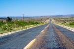
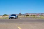
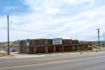
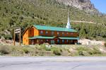
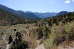
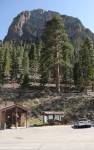
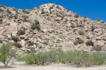
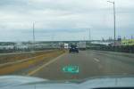
I’m on my way on my penultimate day leaving Slidell, Louisiana at 8.45 on a lovely sunny, blue skied morning and the temperature has already climbed to 76F (24.44C) and soon I join my old friend I-10 going east. About 45 minutes later I have crossed the state line into Mississippi and it must have been raining quite hard earlier on as the highway is pretty damp and spray is being kicked up by the vehicles ahead of me. However, the sky is clear and all is well as 75 miles later I cross over the Pascagoula river basin which is a large area that from the elevated highway spreads almost as far as the eye can see. To the south I can just see an industrial area of some kind with some shipping and to the north it’s swampland and near the horizon it appears to become forested. Eighty seven miles into my journey and I have left Mississippi and crossed into Alabama. One hundred and thirty miles and I see the impressive skyline of Mobile and shortly enjoy a view of the Battleship SS Alabama which I described earlier in my blog and you can view the photographs in my photostream on Flickr, please see the panel on the right hand side of this blog. Having passed Battleship Park I get a great view of the river flowing into the Gulf of Mexico which I did not see at the beginning of my journey as it can only be seen from this side of the highway! The Gulf is at peace, it’s an absolute flat calm without a ripple troubling the boaters out there enjoying the water. One hundred and fifty-four miles on and I have crossed the state line into Florida and I now recognise that this is my penultimate day of my road trip and I suddenly feel excited at the prospect of seeing Diana (a.k.a. She Who Must Be Obeyed) and arriving back in Lakewood Ranch tomorrow but now back on with the day. At Pensacola I leave the Interstate system and take the coastal road heading for todays destination of Panama City Beach. En route I pass through the small town of Gulf Breeze and I’m motoring on a two lane highway through the Naval Live Oak Reservation. This area was designated in 1828 by President Quincy Adams as the First Federal Tree Farm. This was an important area at that time as the Live Oak, which is a member of the beech family was used in the construction of tall ships. As many as two thousand Live Oaks were used to make one hull for a naval vessel!  As I continue along US 98 the landscape becomes a strip development of hotels and shops with an occasional view of the gulf.

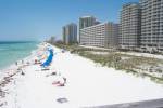
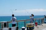
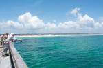
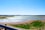
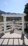
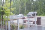
A little further on I leave US98 and cross over a causeway bridge to Navarre and having parked the car I pay the princely sum of $1 for the privilege of walking along the lengthy fishing pier that was constructed in 2010. As I commence my $1 walk I view from the pier on my right hand side a bunch of not very attractive high-rise condominiums and to my left a brilliant white busy beach filled with the Sunday afternoon crowd relaxing, taking some rays! This part of the Gulf of Mexico is fed by a current that brings a prolific quantity of nutrients which colours the water a lovely shade of green which gives rise to the nickname for this part of the coast as “The Emerald Coast”. The throng of anglers on the pier are having a very busy time as they haul in what almost seems to be one fish after another and as I walk towards the end of the pier I find myself dodging anglers making their casts. The flying rods seem to be landing fish with a resounding thump at my feet as I continue to tread delicately over the writhing fish before they are scooped up by the anglers, de-hooked and returned to the ocean deep. I have just encountered an angler who has just returned a 35 pound Redfish to the sea as it was too big to keep! The angler would only be permitted to keep his catch of this variety provided the fish weighed not less than 18 pounds and not more that 27 pounds so, over the side of the pier this one went. Well, that not strictly true. This huge fish was gently lowered in a net to the ocean beneath the pier and then released from its captivity and some people think this is fun! All in all I think my $1 fee was good value. However, if I had been a fisherman I would have had to have paid $2! A little further on I break for lunch at Beasley Park in Ocaloosee Island and sit in a pavilion overlooking the beach. Having enjoyed my lunch I continue my journey and arrive at my destination at Panama City Beach for the night and tomorrow I start my final day of my journey and I’m now looking forward to returning to my American home.

For the techies out there mileage covered today was 290.1 at an average of 46.4 mpg and achieved 22.2 mpg.

Until my next post, Toodleoo!

Cadillac Ranch, The Other Memphis & A Tornado Shelter!


Today has been one of my best drives of this road trip so far! Probably because very little of it was on the Interstate network and I saw some interesting stuff and met some fascinating people.

My day started late as I had a bit of a lazy lie in bed and did not leave the hotel until 09:50. My first stop was just four miles away at The Cadillac Ranch in Potter County, Texas. This is a public art installation and sculpture in Amarillo, Texas, U.S. It was created in 1974 by Chip Lord, Hudson Marquez and Doug Michels, who were a part of the art group Ant Farm, and it consists of what were (when originally installed during 1974) either older running used or junk Cadillac automobiles, representing a number of evolutions of the car line (most notably the birth and death of the defining feature of mid twentieth century Cadillacs; the tail fin) from 1949 to 1963, half-buried nose-first in the ground, at an angle corresponding to that of the Great Pyramid of Giza in Egypt. I lifted this information from the font of all knowledge “Wikipedia” and I have my doubts as to the accuracy of the angle that these cars have been buried. However, I took several photographs of this installation and you can see some of them below and others on my Flickr photo stream. Just click on the “More Photos” link in the Flickr panel on the right hand side of this blog. You would really help me dear reader if you would leave your comment on the Flickr site as to which of these Cadillac photos you like as I’m having a tough time picking just one!

Forty minutes later and I’m now on route for Dallas having thoroughly enjoyed walking around the graffiteed Cadillacs and on the slip road at 10:45 I saw a puppy dog standing over a lawn sprinkler cooling off and then nonchalantly walking off with a good shake. Thirty miles later and I have left the I-40 east and joined the US 287 South in the direction of Fort Worth. On either side of this dual split highway lies rolling green pastureland as far as the eye can see with an occasional small herd of cattle doing what comes naturally. Later the pasturelands change to newly planted very well irrigated wheat fields.

I decided to have a walk around a very small town named Claude and spotted a beautiful library building almost opposite which could only be described as a somewhat decrepit city hall. I noticed that discreetly tucked in the corner of the library was a portable barbecue, see if you can spot in the photograph and it made me wonder what the librarian was having for lunch! Leaving Claude the scenery changed as the landscape to my north became dotted with giant rolls of hay and to my south ploughed land planted and irrigated by those long metal structures that remind me of a wing from an ancient biplane.

Ninety miles into my journey I stopped at the Donley County Safety Rest Area to answer the call of nature and afterwards I walked around the information centre which was very well laid out and presented. You can see a couple of pictures of the interior of this information centre on my Flickr photostream.

My next port of call was just down the road at Memphis, Texas not too be confused with the one in Tennessee! I was walking around the red pavered road taking some pictures of this small pretty town and I noticed a bumper sticker “I STOP FOR QUAIL”. Now that’s not the sort of thing you see in England every day and I stopped to photograph it. Just at that moment the lady owner of the vehicle popped out of a shop and spoke with me. This charming lady of indeterminate years invited me in to see her art collection that was being hung in preparation for a sale at the weekend. While viewing this most attractive collection of western paintings (some were better than others) another lady entered the emporium and was introduced to me. This lady became very excited upon meeting me and it’s fair to say that it’s not that often I have that affect upon members of the opposite sex! However, when this lady invited me to come with her next door to sign her visitors book I understood that it was in her capacity as the office manager of the Memphis Chamber of Commerce. We had a pleasant conversation while I duly signed her book and Susan McQueen, for that is her name, told me that she would relay our meeting to the members of the chamber at the next meeting. I don’t think an awful lot goes on in this pretty little town but in listening to Susan’s enthusiasm I’m sure things will change. As an example there is a very pretty historical hotel which is currently being refurbished so perhaps that town in Tennessee may have to rely a little more than just Elvis to remain the one that everybody remembers!

Leaving Memphis I noticed that it was 102F (38.89C) and was soon on my journey with fields of ploughed red earth either side of the highway which soon gives way to fields of golden wheat which is very picturesque. I stopped for lunch at The Dairy Queen in Childress (population 6,109) and suffered a near edible grilled sandwich of the famous rubber chicken variety.

After 166 miles on I stopped at Hardman County Safety Rest Area for a quick break and was comforted to note that this particular rest area boasted a tornado shelter which was about the size of a large utility room in a modern home. I suppose that if one of those frightening phenomena are bearing down upon you it doesn’t matter how cosy it would get in the shelter! Thirty miles later and I drive through a small town called Vernon. This must have been a massive seed producing area as within the town there is a huge factory reminiscent of a Lancashire cotton mill that was called the Crown Seed Company. Massive towers, broken windows, rusting machinery and a general air of dilapidation.

After 238 miles I’m now approaching Wichita Falls and I have joined the I-44 west and the skyline of this sizable town is ahead of me. The Interstate system took me over and through Wichita Falls and I am now traveling along US 82 East. Just over 330 miles into my drive and I have joined TX114 which will take me into Dallas which is about 40 miles away. This last piece of my journey is conducted in rush hour traffic and I’m pleased when I arrive at my hotel and I promise myself a soak in the bath!

For the techies among you the mileage covered today was 371.2 at an average speed of 59.4 mph and achieved 23.9 mpg.


Until my next post, Toodleoo!

I’m On My Way To Amarillo da, da.


Wednesday May 2.

Well did you sing the title? Originally recorded by Tony Christi, and then by Sir Tom Jones latterly by Peter Kaye and now you! Now that I’ve planted that seed I bet that tune will be rattling around your head for the rest of the day! I left Gallup just after 9am (Mountain Standard Time) and Gallup is not the sort of place one would wish to stay in for any length of time so I’m pleased to be on my journey. My journey today takes me east along I-40 and fortunately it runs parallel to or near to historic route 66 and I’m able to divert from one to the other as the mood takes me. Route 66 is a simple highway, one lane in each direction and therefore, is a lot slower than the modern Interstate system but on the Interstate you just don’t see as much stuff. Fortunately, route 66 carries very little traffic and that allows you to stop and stare.

My route starts on the I-40 and having left Gallup I’m soon barreling along through the Rockies and the scenery is dramatic. Red sandstone bluffs on either side of me with a prairie in between and its easy to imagine this as cowboy country. Soon I see a sign for The Continental Divide and decide to investigate. I pull off route 66 at the sign and take in the view and if you have a look at the photographs below and also by clicking on “more photos” in the Flickr panel on the right hand side, you will see the divide. I’m facing north so the rain that falls to my right (east) will drain towards the Atlantic and that which falls on my left goes west towards the Pacific. This is a first for me as I don’t think I have ever straddled a continental divide before.

Seventy miles on the landscape has become dominated by limestone rather than sandstone and I’ve passed a number of farmsteads but the land is so poor I have no idea how they make their living. Having travelled about 100 miles on a mixture of both highways I leave the I-40 again for the 66 to investigate a small town called Old Laguna. This tiny ramshackle town is comprised mainly of adobe style dwellings and would appear to be populated by native Americans, have a look at the photograph below and on my Flickr photo stream.

After journeying for 200 miles I stopped at a rest station and look back west and its obvious that I have now left the Rockies and I’m traveling through pastureland of a sort as it appears to be very dry. Later I stopped at the world famous “Clines Corners” although I must admit until now I had never heard of it and having replenished the tank in my Corvette and my inner tank with a 6 inch Subway I had a look around their world famous store full of moccasins, boots and other stuff that I didn’t know that I needed and still don’t!

Shortly after leaving Clines Corners the scenery changed to Pine forrest and 88 miles further on I’m surrounded by red stone bluffs and I’ve seen a sign for Lake Conchas state park. It was 24 miles off my route but I decided to go and have a look and turned on the 66 and was confronted with a derelict filling station (see the picture below) and I’m now heading north on a deserted road. Soon I reach Lake Conchas which must have been made by building a dam and there is no one around but there is signs of boating, marina storage etc. The lake is pretty low and I’m feel that I’m at a fairly decent altitude but the whole place is deserted and very windy. I leave Lake Conchas traveling east on NM 104. I have descended from Lake Concas and reached a village called Tucari which is at an elevation of 4000 feet.

Back on the I-40 east and having journeyed for 399 miles I have left New Mexico and entered Texas and changed time zones from Mountain Standard Time to Central Time. Finally I reach my hotel in Amarillo feeling a little weary but pleased with the experiences of the day!

For the techies out there. Mileage covered today was 458.3 at an average speed of 64.4 mph and achieved 24.3 mpg.

Las Vegas to Gallup, New Mexico via The South Rim at The Grand Canyon, Arizona


Tuesday May 1.

This will be one of those days that will be inevitably etched in my mind. After bidding a fond farewell to my lovely wife, Diana a.k.a. She Who Must Be Obeyed. I took my leave of the Bellagio Hotel in Las Vegas and set forth for Gallup in New Mexico via The South Rim of The Grand Canyon in Arizona. My journey started eastwards on the I-215 under bright overcast conditions and having reached Boulder City and turning right onto the I-93 near The Hoover Dam I observed spectacular red rock scenery. Suddenly having gone around a fairly decent bend in the road an impressive vista of Lake Mead hove into view (for pictures please see my previous post “A Dam’ Fine Excursion) and having covered just over 34 miles I have left Nevada and entered Arizona. After a total of 46 miles I stopped at a scenic overview on the Nevada Highway and enjoyed a wondrous view of the Colorado River (see picture below). I stopped to fill the Corvette up at Kingman just before turning east on the I-40 at the foothills of the Rocky Mountains and opposite the filling station stood a rather rickety gaming establishment which I was reliably informed by the filling station cashier “Wuz where all them big guns hung aat”.

After about 150 miles I’m on a high plateau in the Rockies and the excellent scenery that is rolling by the window is a mixture of pasture land, forested areas, scrub and some horse country. The plateau descends into a tiny town on route 66 called Ashfork and I decided to visit the museum. The museum is free and I am encouraged by a member of staff who outnumber the visitor (me) by 4 to 1 and I peruse the exhibits which were of interest. I particularly enjoyed the fire engine and for this and other photographs please click on “More Photos” in the Flickr panel on the right hand side of this blog and then navigate to day 14. After leaving Ashfork and nearing the turn off for the road which will lead me to the South Rim of The Grand Canyon the scenery changes and becomes reminiscent of the Alpine scenery one would find in the Austrian Tyrol on a summers day. At 221 miles I have turned north onto AZ 64 and am headed up to The Grand Canyon. The road steadily climbs and the road runs through a pine forest and the aroma is gorgeous. I’m beginning to hum snatches from Elgar’s Variations, it’s just that sort of road.

Finally I arrive at the entrance to the park and I notice that the entry fee is $25. So, I reach for my wallet and get out the plastic and my Florida driving license for photo ID. The very nice park ranger makes the assumption that I’m a 63 year old Floridian and therefore I just pay $10 entry fee and receive a pass that now entitles me to free entry to all the national parks in the USA for life and that also covers anyone (up to three people) in my car! What a bargain! I commence my 13 mile journey along the South Rim and to say that it’s spectacular is an understatement. It takes me more than two hours to cover this paltry distance and I wish that I had much more time to spend in this beautiful place.It is indeed, one of the wonders of the world and if you can’t get there soon, then please have a look at all the photographs that I have taken on Day 14 of my Flickr photo stream. I have to say that I think my photographs are pretty good and please leave some comments on them and be sure to tell me which one you think is the best one. I’m having a very tough time trying to make the choice!

All too soon I leave The Grand Canyon and at mile 309 I’m driving south-east on my way to Flagstaff and then onto Gallup. At mile 343 I’m on the US 89 and I’m skirting The Painted Desert and once more I wish I had time to stop and stare. I reach Flagstaff after a total of 389 miles and pick up the I-40 east towards Gallup and I’m at an elevation of 6000 feet and that’s after I have descended from the South Rim of the Grand Canyon! I continue my downward journey and after another 35 miles I’ve dropped a further 1000 feet and I’m in Geronimo country. I’m about 80 miles west of Gallup and the scenery puts me straight into a cowboy movie. You expect to see teeming herds of Buffalo and hordes of native Americans between the flat topped eroded mesa’s on either side of the roadway and that big band theme tune from “The Big Country” is rattling around in my head followed by the whistling “The Good, The Bad & The Ugly”. I’m now off the I-40 and on historic route 66 as the sun is setting behind my left shoulder and I begin to feel like a High Plains Drifter. Oh! very cherooted Clint Eastwood indeed, as I leave Arizona and enter New Mexico. At long last I arrive at my hotel in Gallup which is a town that you would just spend one night in because you’re too tired to travel any further. Tomorrow I’m going to get my kicks on route 66!

For the techies amongst you the mileage covered was 559.5 at an average speed of 61.2 mph and I achieved 23.7 mpg.

Until my next post, Toodleoo!

Thrills, Spills, Snow And A Show.


Sunday 29 May

Having gently awoken She Who Must Be Obeyed from her sonorous slumber and having enjoyed a healthy breakfast (orange juice, muesli, coffee and a huge croissant laden with butter and preserve) we put best foot forward and in no time we had collected my Corvette from the valet. A gentle drive down Las Vegas Boulevard on a Sunday morning brought us to our destination, The Stratosphere! We took the lift (elevator for my American readers) which speedily rose the 1,149 feet to the observation deck where we enjoyed the views over Las Vegas. Not only did we gaze in wonder at the wondrous panorama but at the congenital idiots that paid good money to be sent spinning out into the atmosphere on reputedly the highest roller coaster in the world. We were also amazed at the foolhardy that had forked out $149.00 to be attached to wire and then flung off the top of the building hurtling down to the ground 1,149 feet below. If you look closely at one of the photographs below you will see a person in a blue overall plummeting towards the earth’s surface allegedly seeking entertainment. To see a larger image just click on the photo or click on the Flickr links on the right hand side of this blog to see images of the day and navigate to Day 12.

By now the temperature in Las Vegas had risen to 87F (30.5C for my British readers) and we decided to drive out to Mt. Charleston about 40 miles away. We were soon climbing steadily enjoying the scenery and breathing in the pine laden scent which was superior to the artificial aroma emitted by some popular lavatory cleaning agents. We stopped for lunch at a ski lodge opposite Mt. Charleston Baptist Church (have you noticed that where there is a church there’s always a hostelry of some description?) at an elevation of 6000 feet and the temperature was a pleasant 65F (18.33C) although She Who Must Be Obeyed was making noises about getting her fur lined cape out of the boot (trunk) of the car! Fortunately, for all concerned, on this beautiful sunny day there was a blazing log fire inside the lodge! Continuing our healthy eating regime we lunched upon a chicken salad wrap accompanied with deep goose fat fried potatoes and to stay healthy we had unsweetened iced tea to which She Who Must Be Obeyed added a small quantity of aspartame.

After enjoying the vista from the terrace and being duly fortified we continued the assault on Mt. Charleston summit and we reached as far as we could go at an elevation of 8000 feet at the foot of the aptly named Cathedral Rock. By now the temperature was a refreshing 57F (13.89C) and She Who Must Be Obeyed retired to the heated seats of our chariot. It was amazing that within such a short distance one could leave the frenetic activity and desert temperatures of Las Vegas and enjoy such tranquil scenery and naturally pine scented fresh air! Please feel free to view todays photographs by clicking on “More Photos” in the Flickr panel on the right hand side of this blog.

We returned to our sumptuous room at the Bellagio in good time to change for our group dinner which was at the Milos restaurant at the Cosmopolitan. Then we were treated to the spectacular Cirque Du Soleil show in the “O” theatre at the Bellagio. I cannot find an adjective to describe this wonderful, ephemeral event (OK just two then) and I had to keep reminding myself that this 1800 seater theatre with its swimming pool set in the stage, that holds over a half million gallons of water is inside a hotel! This show was breathtaking and from now on I will look upon synchronised  swimming in a different light. If you ever get the chance to see this spectacle then go and enjoy!

Until my next post, Toodleloo!

A Dam’ Fine Excursion


Friday 27 of April

We’re off with the group to a tour of The Hoover Dam. A monumental project that was finished in 1938 two years ahead of time and beneath budget!! Where have we gone wrong?

The coach ride out was through pleasant scenery and then upon arrival the coach and the assembled company was subjected to security which has only to be expected in today’s age. In a few minutes we were whisked down into the depths of The Hoover Dam where we were treated to an overview by the dam’ tour guide, Eric. While in this chamber we could feel the floor vibrate from the flow of water through one of the tunnels beneath, at an impressive speed likened to the emptying of 144 Olympic size swimming pools every minute! One side of the dam is in Nebraska and the other in Arizona and on each side, buried in the structure of the dam, lies nine monstrous turbines which generates electricity for well over a million homes in the area.

Having regained the surface and with the sun beating down upon collective bodies it was time for a stroll across the top of the dam. It was a pleasure to see a number of Morgan Sports cars roll by in convoy particularly as they are one of the last British hand made sports cars still in production!

Now it was time for lunch aboard a paddle steamer, The Dessert Princess, while we cruised Lake Mead which is the largest man made lake in the USA with a coast line of over 550 miles!

All too soon it was back on the coach and back to Vegas stopping at a chocolate factory that manufactured M&M’s. Having whizzed through the factory and dutifully munched my free sample I was able to spend some happy minutes in the Cactus Garden photographing some of the more unusual species.

On the way to our hotel we stopped at the famous Las Vegas sign and were able to get a group photograph underneath this illustrious structure. Back at the hotel there was just time for a quick shower and change and then we attended our gala dinner where a good time was had by all.

To see all the photographs that were taken on this day and some of them are really cool, just click on the Flickr link in the right hand side of this blog.

Until my next post, Toodleloo!

Time zones and unexpected meetings!


I awoke this morning refreshed after a very good nights’ sleep at the Hampton Inn in Las Cruces, so much so that I did not start my journey until 9.20. The sun was up, the sky was blue and the traffic was light but all of a sudden, 20 miles on and I’m in a slow moving line of vehicles and to my amazement we are all being inspected by the US border patrol. Somehow, I was able to convince the very nice officer that I was not an illegal immigrant but an honest, legal alien with a B1/B2 Visa in good order. Somewhat ironic as in today’s newspaper (USA Today) one of the lead stories on the front page is that more Mexicans are leaving the USA than are entering it!

The landscape is becoming more and more arid as I travel west on this high plateaux ringed by majestic but near barren mountains. I pass several large bright yellow signs warning me to be aware of possible dust storms and not to stop in travels lanes and that visibility could be reduced to zero!

Sixty-seven miles into my journey and I have just gone past a stationary Union Pacific locomotive looking like its been abandoned by the side of the road and just six miles later I overtake a person on a push bike! I have to say person because the human figure was shrouded in a voluminous yellow garment and the head was similarly covered with a helmet while the face of the mystery rider was obscured by a mask. I suspect this protective clothing may have been in place not just for protection from the sun that by now is beating down fiercely upon the highway but perhaps as a precaution agains a sudden dust storm! This human form was certainly a change from the more usual figure clad in Spandex which can, upon occasion, be quite revolting and surely should only be worn at private parties but I digress.

I shifted time zones yet again and I’m now in Mountain Standard Time which means as I write this it’s 10:30 pm here in Scottsdale, Arizona; 12:30 am in Huston Texas, 01:30 am in Florida and 6.30 am in the UK. If I’m feeling evil enough when I have finished this post I might just start telephoning a few people in the UK to make sure they are up and working!

Meanwhile, 140 miles into today’s journey and I have crossed the state line into Arizona. This is the centennial year of Arizona. On February 14, 1912, after nearly 49 years as a U.S. territory and thousands of years as a sacred home to indigenous peoples, Arizona became the 48th and last of the contiguous states to enter the Union of the United States of America.

The landscape becomes increasingly arid and large cacti are now a prominent feature of the roadside vegetation.

I decided to take a break and do a little shopping in Tucson (I needed some clean socks before I meet my dear wife, Diana, a.k.a. She Who Must Be Obeyed tomorrow in Las Vegas) and while in the mall I met a lady that I haven’t seen for eighteen years! Bonnie Allen and her husband Rod were part of a business that Diana (S.W.M.B.O.) and I pioneered in the UK. We had a ten minute catch up and went our separate ways, Bonnie back to her retail managerial position and me back to the Corvette!

Three hundred and forty six miles into my journey and I espy traveling in the opposite direction on the railway track adjacent to the highway a colossus of a freight train. This behemoth was double stacked with containers and seemed to slither like a serpent for a considerable period of time. It was interesting to note that each container had painted on its side the words “China Shipping” which may be indicative of some of our western economic challenges.

Finally I have arrived at my hotel in Scottsdale and I’m looking forward to my journey tomorrow to Las Vegas and willingly subjecting myself to She Who Must Be Obeyed.

For the techies out there the mileage covered today was 414 miles at an average speed of 68.4 mph and achieved 18.5 mpg.

Until my next post, Toodleloo!

Houston, We have a problem!


Well not exactly but more of that later. I awoke this morning bright and early and had a short run (nearly two miles) around Battleship Park in Mobile, Alabama. A lovely way to start the day, the sun was up and after showering I enjoyed a some Eggs Benedict and off in the car with my destination being Houston.

Just twenty-nine miles later I crossed over the state line from Alabama to Mississippi. Almost immediately the scenery changed from the majestic oaks of Alabama to that of a wetlands area similar to the Everglades in Florida but not as flat!

I decided to take a break at about 100 miles of driving and at 104 miles I found myself at The NASA facility in Hancock County. So, I thought that I would take a look. I was exceptionally disappointed, not because of the quality of the exhibit but because I was denied entry to the tour because I did not have my UK passport with me! I have never been asked for it at Space Kennedy Centre in Florida and I telephoned and checked with the NASA facility in Houston and they do not require me to show my passport. Bizarre! Oh, well!

Just down the road I stopped at a road side rest area and it was one of the finest buildings I have seen. It was just like an antebellum house, beautifully presented. Have a look at the photograph at the end of this post.

Fourteen miles later and I’ve crossed the state line into Louisiana. The countryside has changed again to a vast collection of swamp like waterways. If you have ever watched Swamp People on the History Channel you will get the idea. Having gone through Baton Rouge I went over an incredibly long piece of suspended roadway above the Atchafalaya river basin (the largest river basin in the USA covering nearly a million acres) and stopped at its visitor centre. This looks like a fascinating area and one that I would like to spend some time in at some point in the near future to view the enormous array of wildlife.

After traveling a total of 280 miles the swampland completely disappears and becomes cultivated farmland which extends a considerable distance. Eighty miles further on and I have started to run into some ominous looking very dark clouds. Seven miles further on and I cross the state line into Texas. Traveling on the Interstate through Beaumont you can smell the petrochemical plants as well as see them. It’s an alien, industrial, ugly landscape.Having left the city limits it started to lightly rain. By 4.15 pm the sky is nearly black and I have seen forked lightning on the horizon.

I decided to answer the call of nature and stopped at a road side rest area near Orange. Just as I was about to leave a family arrived in their open truck and started carrying in their golf apparel into the rest area building. They had heard a severe weather warning on the wireless, 60 mph winds, hail, thunder etc and it was about to arrive. I felt it prudent to wait with them and indeed the storm blew in with boiling clouds, strong winds, thunder, lightning and heavy rain but no hail stones. The good thing was that the storm washed all the bugs off the front of my Corvette! Soon, the rain had eased and I was able to continue my journey.

The last 45 minutes of my journey on T146 South, which is a regular four lane highway, was fairly difficult due to the levels of surface water and the quantity of traffic so, I was really pleased to arrive at my hotel. A quick wash & brush up and I walked across to a local restaurant and dined on stuffed Jalapeños and a platter of grilled mixed fish.

I’m looking forward to tomorrow and the forecast promises to be good. For the techies out there I have covered today 475.10 miles at an average speed of 63.4 mph and achieved an average of 22.3 mpg.

To my next post, toodleloo!