I’m On My Way To Amarillo da, da.


Wednesday May 2.

Well did you sing the title? Originally recorded by Tony Christi, and then by Sir Tom Jones latterly by Peter Kaye and now you! Now that I’ve planted that seed I bet that tune will be rattling around your head for the rest of the day! I left Gallup just after 9am (Mountain Standard Time) and Gallup is not the sort of place one would wish to stay in for any length of time so I’m pleased to be on my journey. My journey today takes me east along I-40 and fortunately it runs parallel to or near to historic route 66 and I’m able to divert from one to the other as the mood takes me. Route 66 is a simple highway, one lane in each direction and therefore, is a lot slower than the modern Interstate system but on the Interstate you just don’t see as much stuff. Fortunately, route 66 carries very little traffic and that allows you to stop and stare.

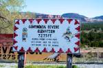
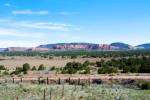
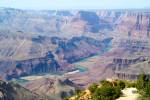
My route starts on the I-40 and having left Gallup I’m soon barreling along through the Rockies and the scenery is dramatic. Red sandstone bluffs on either side of me with a prairie in between and its easy to imagine this as cowboy country. Soon I see a sign for The Continental Divide and decide to investigate. I pull off route 66 at the sign and take in the view and if you have a look at the photographs below and also by clicking on “more photos” in the Flickr panel on the right hand side, you will see the divide. I’m facing north so the rain that falls to my right (east) will drain towards the Atlantic and that which falls on my left goes west towards the Pacific. This is a first for me as I don’t think I have ever straddled a continental divide before.

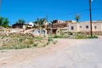
Seventy miles on the landscape has become dominated by limestone rather than sandstone and I’ve passed a number of farmsteads but the land is so poor I have no idea how they make their living. Having travelled about 100 miles on a mixture of both highways I leave the I-40 again for the 66 to investigate a small town called Old Laguna. This tiny ramshackle town is comprised mainly of adobe style dwellings and would appear to be populated by native Americans, have a look at the photograph below and on my Flickr photo stream.

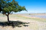
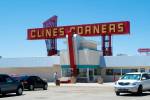
After journeying for 200 miles I stopped at a rest station and look back west and its obvious that I have now left the Rockies and I’m traveling through pastureland of a sort as it appears to be very dry. Later I stopped at the world famous “Clines Corners” although I must admit until now I had never heard of it and having replenished the tank in my Corvette and my inner tank with a 6 inch Subway I had a look around their world famous store full of moccasins, boots and other stuff that I didn’t know that I needed and still don’t!

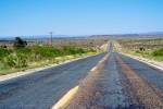
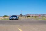
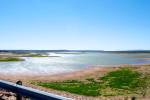
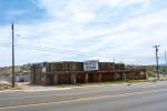
Shortly after leaving Clines Corners the scenery changed to Pine forrest and 88 miles further on I’m surrounded by red stone bluffs and I’ve seen a sign for Lake Conchas state park. It was 24 miles off my route but I decided to go and have a look and turned on the 66 and was confronted with a derelict filling station (see the picture below) and I’m now heading north on a deserted road. Soon I reach Lake Conchas which must have been made by building a dam and there is no one around but there is signs of boating, marina storage etc. The lake is pretty low and I’m feel that I’m at a fairly decent altitude but the whole place is deserted and very windy. I leave Lake Conchas traveling east on NM 104. I have descended from Lake Concas and reached a village called Tucari which is at an elevation of 4000 feet.

Back on the I-40 east and having journeyed for 399 miles I have left New Mexico and entered Texas and changed time zones from Mountain Standard Time to Central Time. Finally I reach my hotel in Amarillo feeling a little weary but pleased with the experiences of the day!

For the techies out there. Mileage covered today was 458.3 at an average speed of 64.4 mph and achieved 24.3 mpg.

Las Vegas to Gallup, New Mexico via The South Rim at The Grand Canyon, Arizona


Tuesday May 1.

This will be one of those days that will be inevitably etched in my mind. After bidding a fond farewell to my lovely wife, Diana a.k.a. She Who Must Be Obeyed. I took my leave of the Bellagio Hotel in Las Vegas and set forth for Gallup in New Mexico via The South Rim of The Grand Canyon in Arizona. My journey started eastwards on the I-215 under bright overcast conditions and having reached Boulder City and turning right onto the I-93 near The Hoover Dam I observed spectacular red rock scenery. Suddenly having gone around a fairly decent bend in the road an impressive vista of Lake Mead hove into view (for pictures please see my previous post “A Dam’ Fine Excursion) and having covered just over 34 miles I have left Nevada and entered Arizona. After a total of 46 miles I stopped at a scenic overview on the Nevada Highway and enjoyed a wondrous view of the Colorado River (see picture below). I stopped to fill the Corvette up at Kingman just before turning east on the I-40 at the foothills of the Rocky Mountains and opposite the filling station stood a rather rickety gaming establishment which I was reliably informed by the filling station cashier “Wuz where all them big guns hung aat”.

After about 150 miles I’m on a high plateau in the Rockies and the excellent scenery that is rolling by the window is a mixture of pasture land, forested areas, scrub and some horse country. The plateau descends into a tiny town on route 66 called Ashfork and I decided to visit the museum. The museum is free and I am encouraged by a member of staff who outnumber the visitor (me) by 4 to 1 and I peruse the exhibits which were of interest. I particularly enjoyed the fire engine and for this and other photographs please click on “More Photos” in the Flickr panel on the right hand side of this blog and then navigate to day 14. After leaving Ashfork and nearing the turn off for the road which will lead me to the South Rim of The Grand Canyon the scenery changes and becomes reminiscent of the Alpine scenery one would find in the Austrian Tyrol on a summers day. At 221 miles I have turned north onto AZ 64 and am headed up to The Grand Canyon. The road steadily climbs and the road runs through a pine forest and the aroma is gorgeous. I’m beginning to hum snatches from Elgar’s Variations, it’s just that sort of road.

Finally I arrive at the entrance to the park and I notice that the entry fee is $25. So, I reach for my wallet and get out the plastic and my Florida driving license for photo ID. The very nice park ranger makes the assumption that I’m a 63 year old Floridian and therefore I just pay $10 entry fee and receive a pass that now entitles me to free entry to all the national parks in the USA for life and that also covers anyone (up to three people) in my car! What a bargain! I commence my 13 mile journey along the South Rim and to say that it’s spectacular is an understatement. It takes me more than two hours to cover this paltry distance and I wish that I had much more time to spend in this beautiful place.It is indeed, one of the wonders of the world and if you can’t get there soon, then please have a look at all the photographs that I have taken on Day 14 of my Flickr photo stream. I have to say that I think my photographs are pretty good and please leave some comments on them and be sure to tell me which one you think is the best one. I’m having a very tough time trying to make the choice!

All too soon I leave The Grand Canyon and at mile 309 I’m driving south-east on my way to Flagstaff and then onto Gallup. At mile 343 I’m on the US 89 and I’m skirting The Painted Desert and once more I wish I had time to stop and stare. I reach Flagstaff after a total of 389 miles and pick up the I-40 east towards Gallup and I’m at an elevation of 6000 feet and that’s after I have descended from the South Rim of the Grand Canyon! I continue my downward journey and after another 35 miles I’ve dropped a further 1000 feet and I’m in Geronimo country. I’m about 80 miles west of Gallup and the scenery puts me straight into a cowboy movie. You expect to see teeming herds of Buffalo and hordes of native Americans between the flat topped eroded mesa’s on either side of the roadway and that big band theme tune from “The Big Country” is rattling around in my head followed by the whistling “The Good, The Bad & The Ugly”. I’m now off the I-40 and on historic route 66 as the sun is setting behind my left shoulder and I begin to feel like a High Plains Drifter. Oh! very cherooted Clint Eastwood indeed, as I leave Arizona and enter New Mexico. At long last I arrive at my hotel in Gallup which is a town that you would just spend one night in because you’re too tired to travel any further. Tomorrow I’m going to get my kicks on route 66!

For the techies amongst you the mileage covered was 559.5 at an average speed of 61.2 mph and I achieved 23.7 mpg.

Until my next post, Toodleoo!

%d bloggers like this: